
Geospatial Intelligence / Humanitarian Technology
Atlas GIS
Programme Intelligence & Humanitarian Impact Platform
An enterprise-grade geospatial intelligence platform for humanitarian programme analysis, climate vulnerability assessment, funding disparity detection, spatial planning, and resource optimization.
Status note: Atlas GIS is a working prototype. It is not represented here as a production institutional deployment or a certified/endorsed system.
Screenshots
Inside Atlas GIS
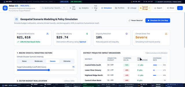
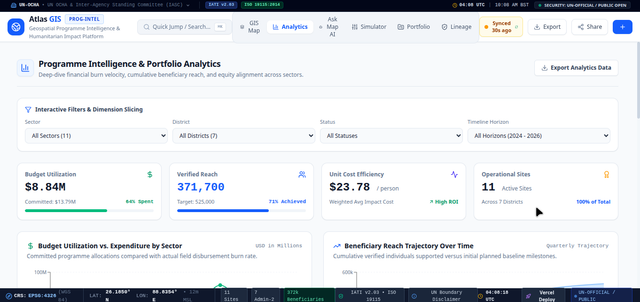
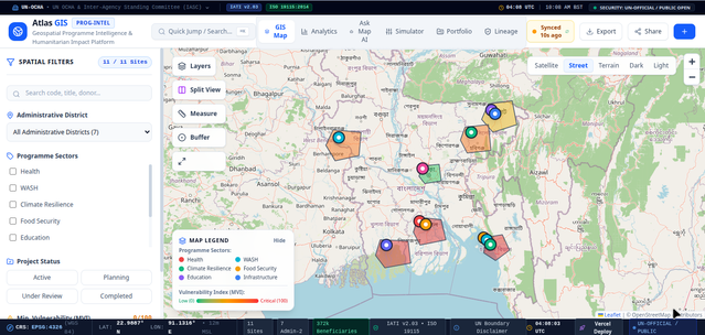
Prototype interface views — map layers, split comparison, and dashboard panels.
Core Capabilities
A spatial intelligence toolkit for programme decisions.
Mapping, comparison, navigation, and AI-assisted reasoning layered on top of a shared geospatial data model.
Multi-Layer GIS Cartography
Leaflet-based interactive mapping across administrative, thematic, and analytical layers.
- Administrative boundary visualization
- Intervention-site mapping
- Satellite, Street, Terrain, Dark & Light basemaps
- Vulnerability choropleths
- Climate hazard corridors
- Funding disparity visualization
- Beneficiary density & heatmap / KDE rendering
Analytical Operations
Core spatial computation underlying every map layer and query.
- Buffer-distance analysis
- Point-in-polygon analysis
- Geodetic distance and bearing measurement
- Heatmap / kernel density estimation
Split-Map Comparison
The SplitMapViewer places two synchronized maps side by side for direct sectoral comparison.
- Synchronized pan and zoom
- Independent layer controls per pane
- Sector comparison workflows
- Vulnerability vs. climate risk
- Health vs. WASH
- Funding disparity vs. beneficiary saturation
Global Command Palette
A ⌘K / Ctrl+K interface for moving through the platform without touching the mouse.
- Project search
- District & sector search
- Spatial navigation
- Quick actions & dataset export
- Scenario simulator & guided tour launch
- Split-map launch
Ask Map AI
A natural-language spatial copilot for exploring the dataset conversationally. Recommendations are informational — not authoritative decisions — and should be verified before use in planning.
- Natural-language geospatial queries
- Spatial reasoning & district/site highlighting
- Map auto-focus on relevant areas
- Structured analytical responses
- Resource allocation suggestions (advisory only)
- Gemini-powered reasoning, with a heuristic fallback for edge/offline scenarios
Scenario Simulator
Budget reallocation modelling across sectors, with a before/after spatial delta view.
- Budget reallocation sliders
- Sector allocation simulation — WASH, Health, Climate Resilience, Food Security
- Projected disparity reduction (modelled estimate)
- Estimated additional beneficiary reach (modelled estimate)
- Before/after spatial delta visualization
Note: Simulator outputs are modelled estimates for exploration — not real-world forecasts or funding commitments.
Programme Analytics
Portfolio-level visibility, not just a map.
A KPI layer that ties spatial data back to programme management.
Portfolio & Investment
- Portfolio KPI dashboard
- Investment tracking
- Active intervention sites
- Beneficiary reach
- Vulnerable-district coverage
Budget & Project Management
- Sectoral budget analysis
- Funding-gap analysis
- Project CRUD management
- Project status tracking
- Data provenance and lineage
Institutional Standards
Standards & Interoperability
Technical standards the platform is built against or targets. These are engineering references, not claims of formal certification or institutional endorsement.
IATI Activity Standard v2.03 — aid activity data structure.
Geographic metadata standard for spatial dataset description.
GeoJSON specification for interchange geometry.
WGS 84 coordinate reference system.
UN cartographic disclaimer conventions for boundary representation.
Agency Context
Analytical view configurations, not partnerships
Atlas GIS includes view configurations reflecting how different institutions typically frame humanitarian and development spatial data. These are analytical lenses built into the platform — they do not represent official partnerships, endorsements, or data-sharing agreements with the named organizations.
System Design
Architecture
Request flow from the browser through the spatial analysis and reasoning layers.
Frontend
- React 18
- TypeScript
- Vite
UI
- Tailwind CSS
- Lucide Icons
GIS
- Leaflet.js
- Canvas Rendering
- Haversine Geodesics
Visualization
- Recharts
AI
- Google GenAI / Gemini
Backend
- Node.js
- Express.js
- TypeScript
Standards
- IATI
- ISO 19115
- GeoJSON RFC 7946
- EPSG:4326
Data & Provenance
Evidence & Data Lineage
Atlas GIS is designed around traceability — every layer and record is intended to carry its own evidentiary trail.
Export & Collaboration
Take the analysis with you.
Outputs are designed to leave the platform in formats other GIS tools and reporting workflows can use directly.
Technical Credibility
Engineering Highlights
Project Information
At a Glance
Explore Atlas GIS
Explore Atlas GIS
Explore the architecture, spatial intelligence capabilities, and analytical workflows behind Atlas GIS.